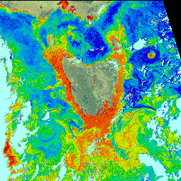
Satellites can directly measure ocean color (and help find fish)§. Microscopic plants (phytoplankton) absorb certain wavelengths of light and reflect others. Mapping ocean color reveals productive areas; where phytoplankton are found, other animals--including fish--are also found.
In just two minutes a satellite collected data for this map of phytoplankton around Tasmania, Australia. Higher concentrations of phytoplankton are shown in red. It would have taken a ship moving at 10 knots an entire decade to collect the same type of data on this area slightly larger than Texas and New Mexico§.
photo courtesy gene carl feldman / National Aeronautics and Space Agency
Satellites can measure ocean surface temperatures, shown in computer-generated colors§. Yellow and red indicate warmer temperatures. The water temperature off Miami, Florida, is 81 F (27 C).
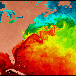 Gulf Stream, western North Atlantic, June 1984
photo courtesy of O. Brown, R. Evans, M. Carle, University of Miami Rosenstiel School of Marine and Atmospheric Science
IUSS is tops for sensing what's on the bottom and in the water§. With the end of the Cold War, the U.S. Navy has identified non-military uses for passive listening devices originally designed to detect enemy-submarine movement. IUSS (Integrated Underwater Surveillance System) has many uses. It allows scientists to monitor volcanic activity and fishing vessels (such as illegal driftnetters), and track ocean currents and migrating whales.
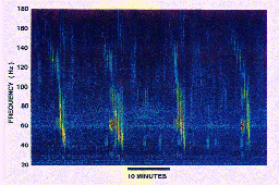
photo courtesy of U.S. Naval Research Laboratory
Spectrogram of a humpback whale song § These four consecutive phrases of a humpback's "song" were recorded by some of the bottom-mounted hydrophones installed around the world's oceans by the U.S. Navy. Naval Research Laboratory Dual Use Analysis Center
![]() Songs of the Humpback Whale (137 kbytes)
Songs of the Humpback Whale (137 kbytes)
![]() Ocean Planet Exhibition Floorplan
Ocean Planet Exhibition Floorplan
![]()