
The images below are from the Press Release Collection of NASA's
Johnson Space Center
Digital Image Collection.
If none of the images appear, the NASA/JSC server may be unavailable.
Please try again at another time.
 You can also watch a short mpeg video clip of Florida taken from the Space Shuttle (346 Mbytes).
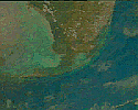
 Photo ID: STS043-605-068
Though much of southern Florida is covered by clouds, the Florida
Everglades and Keys (25.0N, 82.0W) remain relatively clear in this nearly
vertical view. The view covers the Gulf of Mexico port city of Ft. Myers,
and Lake Okeechobee, at the top of the scene, in the north, The
Everglades, in the center and the entire Florida Key Chain at the bottom.
Even with the many popcorn clouds, ground detail and the city of Miami is
easily discerned.
 Photo ID: STS058-107-046
Clouds are seen across central Florida in this photograph which includes
the Florida Peninsula, Andros Island of the northern Bahamas and Cuba
(lower left). The light blue, shallow bank of the Bahamas contrast with the
deeper blue waters of the Florida strait. The city of Miami is obscured by
clouds, but one can see the Florida Keys stretching off to the left. Much
of the rest of the southeast coast is barely visible under haze.
 Photo ID: STS030-84-066
The Florida Peninsula (27.0N, 81.0W) is neatly bracketed between the Earth
Limb across the Gulf of Mexico and the Bahama Banks in the foreground.
Geographic relationships of Cape Canaveral, Lake Okeechobe, the Miami
urban complex and the shallow waters of Florida Bay and the Florida Keys
are displayed in a single well composed photo.
 Photo ID: STS052-153-101
This oblique view documents conditions in South Florida (27.0N, 81.0W) in
the aftermath of Hurricane Andrew that severly mauled south Florida on 24
Aug 92, battering Dade County with a 16.9 ft. storm surge and wind gusts
of up to 169 mph. An additional feature is the band of haze running
across the central portion of the state The band of air pollution has
been drawn from the north by a weak cold front and was focused along the
east/west axis of the front.
 Photo ID: STS031-77-087
This decaying thunderstorm, seen as the trailing edge of a cloud mass over
the Gulf of Mexico and approaching Florida, Bahamas and Cuba (24.0N, 81.0W)
has lost much of its force but still dropped a considerable amount of
rainfall over most of Cuba and Florida. The storm, remnants of the same
front described in scene STS031-77-078, is seen as a thin front stretching
northwest to southeast over the Gulf of Mexico just west of Florida.
 Photo ID: STS050-81-027
Most of south Florida and the space shuttle payload bay (27.0N, 81.0W) can
be seen in this view. The first United States Microgravity Laboratory
(USML-1) module is pictured in the payload bay of the earth-orbiting
Columbia in this scene over the southern two-thirds of the Florida
peninsula. The Kennedy Space Center, where the mission began, can be seen
just above Columbia's starboard wing.
 Photo ID: STS045-78-016
This view is of the Bahamas and Florida (26.5N, 80.0W) looking westward
into the sunglint of the setting sun. The Bahama Banks are in the
foreground; from left to right, Andros Island (the largest), the Berry
Islands and Grand Bahama Island are surrounded by the shallow limestone
banks. Bimini is the two small islands between Florida and the Bahamas.
The western tip of Cuba is at the edge of the scene.
 Photo ID: STS044-80-099
In this view of the Florida peninsula and the Bahamas (28.5N, 80.0W), the
Bahamas are easily identified from orbit because of the vivid blue colors
of the shallow Bahama Banks and dark blues of the ocean depths. The
Florida peninsula is completely silhoutted by cumulus clouds except for
the cloud hole over Lake Okeechobee. The rest of the U.S. Gulf Coast and
eastern seaboard is completely obscured by the clouds of an approaching
winter front.
 Photo ID: STS031-78-000C
The Gulf coast and the Florida peninsula (30.0N, 81.5W) seen in sunglint.
The lakes of central Florida are highlighted in reflected light in this
scene. The view extends up along the Georgia and South Carolina Coast and
clouds cast shadows in the sunglint. The sunglint off the east coast also
highlights shears in the Atlantic related to the Gulf Stream. To the
south, Andros Island and the Grand Bahama Bank are visible.
 Photo ID: STS046-86-064
This unique photo offers a view of the Florida peninsula, western Bahamas,
north central Cuba and the deep blue waters of the Gulf Stream, that hugs
the east coast of Florida (27.0N, 82.0W). In addition to being an
excellent photograph for showing the geographical relationships between
the variety of landforms in this scene, the typical effect of the land-sea
breeze is very much in evidence as few clouds over water, cumulus build up
over landmass.
 Photo ID: STS51C-44-026
Almost the entire state of Florida, USA (28.0N, 81.5W) can be seen in this
single view from space. The large urban area on the SE coast is the
greater Miami, Fort Lauderdale, Boca Raton and West Palm Beach complex.
Half way up the coast is the Kennedy Space Center at Cape Canaveral where
the space shuttle lifts off into space. Even at this great distance, the
huge Vehicle Assembly Building, causeway and launch areas can still be
easily seen.


JASON Project Hompage ||
Teachers' Guide ||
Students' Corner ||
Search
Gene Carl Feldman
(gene@seawifs.gsfc.nasa.gov)
(301) 286-9428
Todd Carlo Viola, JASON Foundation for Education (todd@jason.org)
Revised: 18 Jan 1996
 Photo ID: STS043-605-068
  Photo ID: STS058-107-046
  Photo ID: STS030-84-066
  Photo ID: STS052-153-101
  Photo ID: STS031-77-087
  Photo ID: STS050-81-027
  Photo ID: STS045-78-016
  Photo ID: STS044-80-099
  Photo ID: STS031-78-000C
  Photo ID: STS046-86-064
  Photo ID: STS51C-44-026