![]() If you selected the United States, you will be able to get progressively higher resolution maps of your state, county, town, etc.
If you selected the United States, you will be able to get progressively higher resolution maps of your state, county, town, etc.
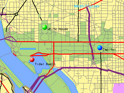
![]() In this example, we will focus in on the Washinton, D.C. area. Let's assume that we will be studying the Tidal
Basin, which is located just to the southwest of the White House. The object of this part of the exercise is to enlarge the map just enough so that you can locate the body of water that you are going to study and "place" the red pin directly on your study site.
As you can see in the map below, the red pin is marking the spot where we will be conducting our study.
In this example, we will focus in on the Washinton, D.C. area. Let's assume that we will be studying the Tidal
Basin, which is located just to the southwest of the White House. The object of this part of the exercise is to enlarge the map just enough so that you can locate the body of water that you are going to study and "place" the red pin directly on your study site.
As you can see in the map below, the red pin is marking the spot where we will be conducting our study.
![]()
The three controls displayed above will help you to navigate directly to your site. By default, each time you click on the map, you will be zooming in. By selecting the "Zoom out" button and then clicking on the map, you will see a larger region. If you just want to locate the red pin and are satisfied with the magnification, use the "Just move" option and click on the location of your site to move the pin.
Once you have successfully identified your site, push the register button and begin to enter your introductory remarks in the space provided.
![]()

![]()
![]()
JASON Project Homepage ||
Teachers' Guide ||
Students' Corner ||
Search
Gene Carl Feldman
(gene@seawifs.gsfc.nasa.gov)
(301) 286-9428
Todd Carlo Viola, JASON Foundation for Education (todd@jason.org)
Revised: 14 Nov 1995