To understand how the JASON VII Expedition is conducting its research on Shark Senses and Ecology, you should read Heidi Kuglin's Expedition Journal entry from April 23, 1996 about tagging sharks entitled On the Trail of Bob and Martha. Also, you can learn more about the details of the research on Shark Science during the April Expedition.
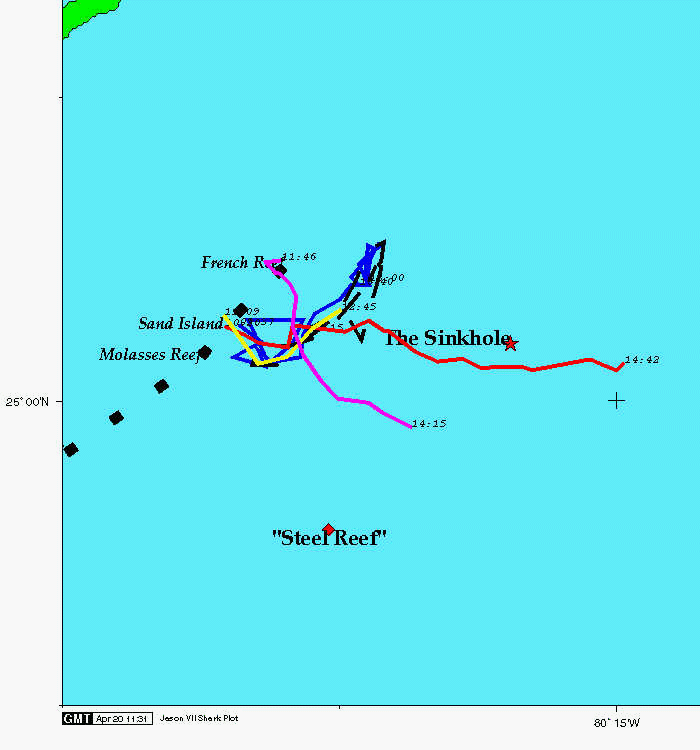 After we tag a shark, we attempt to keep track of the path the sharks make
once they are let free. The data we collect on the tracking boat goes to
the Imaging and Mapping team. They enter the data onto their computer to
produce maps and graphs showing the sharks' movement. With these we look
for patterns in the sharks' activities which might indicate that they have a
preferred territory. Two of the sharks we've tagged so far have remained in
the same area (which we call "Shark Alley") while the other three have moved
out to sea.
After we tag a shark, we attempt to keep track of the path the sharks make
once they are let free. The data we collect on the tracking boat goes to
the Imaging and Mapping team. They enter the data onto their computer to
produce maps and graphs showing the sharks' movement. With these we look
for patterns in the sharks' activities which might indicate that they have a
preferred territory. Two of the sharks we've tagged so far have remained in
the same area (which we call "Shark Alley") while the other three have moved
out to sea.
![]() Jon Howland describes what the shark tracking data contain (60Kbytes)
Jon Howland describes what the shark tracking data contain (60Kbytes)
![]() The mapping team plots the sharks' position over time to produce a
2 dimensional map.
By adding the data about the depth that the sharks swim,
they can produce a three dimensional plot. You can take a look at an
Mpeg animation (195Kbytes)
of one of the shark tracking plots. For example, one of the sharks
that swam out to sea did not simply swim along the surface. Instead we see
that it swam up and down in the water for over seven miles.
The mapping team plots the sharks' position over time to produce a
2 dimensional map.
By adding the data about the depth that the sharks swim,
they can produce a three dimensional plot. You can take a look at an
Mpeg animation (195Kbytes)
of one of the shark tracking plots. For example, one of the sharks
that swam out to sea did not simply swim along the surface. Instead we see
that it swam up and down in the water for over seven miles.
![]() Jon Howland discusses what we see in the three dimensional plot (157Kbytes)
Jon Howland discusses what we see in the three dimensional plot (157Kbytes)
Download the actual shark tracking data files so that you can make your own shark plots.
![]() Back to April Expedition Journal
Back to April Expedition Journal
![]()
![]()
JASON Project homepage ||
Teachers' Guide ||
Students' Corner ||
Search
Gene Carl Feldman
(gene@seawifs.gsfc.nasa.gov)
(301) 286-9428
Todd Carlo Viola, JASON Foundation for Education (todd@jason.org)
Revised: 24 April 1996